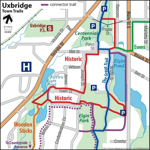
Trail Description:
The Historic Trail connects with Wooden Sticks, Ewen Trail, and part of the Trans-Canada Trail.
The Historic Trail winds through the oldest part of Uxbridge with a ‘Rotary Lookout’ deck over Elgin Pond. The feature of this trail is the series of six historical information plaques that describe Uxbridge life in “the old days” and illustrate what the town looked like, using old photographs and maps.
The trail is mostly on paved streets but has a small section around the Wooden Sticks Retention Pond that may be unsuitable for scooters and wheelchairs. However, many of the historical information plaques are on streets and universally accessible. Elgin Park now has a wonderful, paved connector path which connects the trail from Joseph St. into the Park, making it even more accessible.
Parking at Centennial Park starts you on this trail’s journey past the Trans-Canada Trail Pavilion and through the Ruth Cooper Bird Sanctuary (note the plaque). The trail crosses over a stream and travels south on Pond Street, then turns right at Mill Street.
Centennial Park was part of Uxbridge’s original pond, which was no longer needed for waterpower by the late 1940s. By that time, it had reverted to being a creek, and the pond bottom became the town’s dump. As a Centennial project in 1967, the former pond site and dump became Centennial Park.
A historical information plaque tells the story of the Electric Light Pond – how it got its name, and pictures and history of the old mill and later electricity generating station that was driven by water from the pond. As you’ll see, this area was out in the country, where the highway (now Durham Highway 47) was a gravel road.)
Elgin Park historical information plaque shows pictures of the park from the early years of the last century, including its use as a harness racing track.
The history of the park is described, going back to the 1860s.
A lookout provided by the Rotary Club for a good view north up the length of the pond. There’s a picnic table there, as well as a historical information plaque giving information about Elgin Pond — why it was formed and how it provided much of the waterpower on which early industry in Uxbridge was based.
Water St. contains some fine old houses from the late 19th Century.
The Historic Trail was created as a project of the Rotary Club of Uxbridge, to mark the 100th anniversary of the founding of Rotary International. Generous support also came from the Uxbridge-Scott Historical Society.