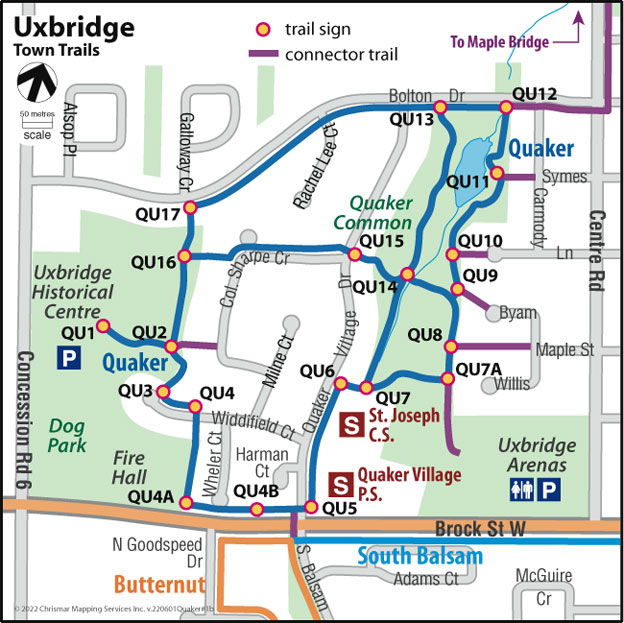
Trail Description:
Is designed as a loop, has loops within the loop, and can be accessed from many locations.
The Quaker Trail begins its journey at the Uxbridge Historical Centre and winds its way down and around the Quaker Village residential area in northwest Uxbridge. It passes through some of the most historic areas of the town’s past and accesses the Uxbridge Historical Centre.
The Uxbridge Historical Centre is a treasure trove of information and artifacts relating to Uxbridge’s past when it was a small but thriving hamlet. The Historical Centre is the site of the first school in the township, a log building built in 1817. This was replaced by a frame schoolhouse, which was in turn replaced by a brick building (1924), which now stands in the museum “village.” There are also displays depicting three prominent residents: Lucy Maud Montgomery, who wrote the “Anne of Green Gables” children’s books; Glenn Gould, world-renowned pianist, and artist David Milne. Picnic tables are available on the grounds, and lots of room for kids to play.
This area was where Joseph Gould, one of Uxbridge’s pioneers, built his home. The Gould family owned all the land covered by the trail and sold parts of it in 1914 to the Carmody family, who farmed the land until selling it in 1952. It continued to be used as pastureland until the 1980s when the Quaker Village development started. Note the “Carmody” name on a nearby street.
The Quaker Common Pond is man-made, designed as a storm-water runoff pond to contain rainwater drainage from the entire Quaker Village area. The pond has developed into a natural wetland area, with blue herons, many other bird species, and many species of fish, including bluegill, perch, sunfish, and largemouth bass. A large snapping turtle also makes his home there.
Finally . . . who is this, Colonel Sharpe? Sam Sharpe (born 1872) was a prominent lawyer and Member of Parliament who raised a local regiment to fight in World War I. He became sick overseas and returned to Canada in 1918. He never made it home to Uxbridge but died in Montreal. Other street names: Rachel Lee was Joseph Gould’s mother, and Milne Court is named after artist David Milne, who lived and worked in an upstairs apartment on Brock Street for many years.
Note: This trail connects easily with 3 other town trails, Maple Bridge, South Balsam, and Butternut Trails.